General
- The plots are useful for better understanding where
different height assignment methods are applied; for example most
high level winds are assigned heights using the
CO2 slicing and WV intercept techniques.
- In general the CO2 slicing plots exhibit the
best statistics at high level and the EBBT/cloud base at lower levels.
- In some cases the plots can be used to better understand
the origin of a speed bias or poor statistics.
|
Meteosat
- The WV intercept and EBBT plots show larger slow speed
biases than the CO2 slicing plots for high level extra-tropical
Meteosat-9 IR and WV winds.
- The IR CO2 slicing zonal plot shows a marked
slow speed bias below 450 hPa in the extra-tropics
(Feature 2.9 in the 3rd analysis report).
|
GOES
- There is little difference in the statistics for winds
assigned EBBT or cloud base heights, although it is worth noting that the latter are
only used over the sea.
- The density plots show there are a few GOES-12 low level winds
assigned CO2 slicing heights. These have a slow speed bias of ~6 m/s.
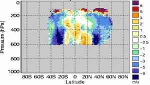
- The GOES winds assigned WV intercept heights show a
large slow speed bias at mid level in the extra-tropics (zonal plot example
shown below, but also see map plots). This was described under Feature 2.9 in the
3rd analysis report
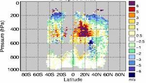
| Unedited GOES-11 IR O-B speed bias
|
| EBBT
| WV intercept
|

| 
|
- The zonal plots of GOES winds assigned EBBT heights show
a marked fast speed bias at 300-500 hPa in the tropics (e.g. above). This only affects a
small number of winds. The unedited GOES-11 IR high and mid level EBBT map
plots show the geographic location of this fast speed bias. Also notice a
slow speed bias off the coast of California (mid level plot).
- Similar to Meteosat-9, the GOES-12 CO2 slicing zonal plot shows two
distinct regions of extra-tropical slow bias (one above 300 hPa and one below
500 hPa).
|
Polar
- There is little difference in the statistics for different
height assignment methods.
- It is worth noting that comparitively few MODIS winds are
assigned WV intercept heights. This method is not available for the AVHRR winds.
|